You Need to Go There! You'll be glad you did.
- Posted On
- Jul 09, 2015
- Category
- Southern Utah
— By Monique Beeley
 Little Grand Canyon
The San Rafael Swell sits dramatically in the southeastern section of Utah. Split by I-70 the Book Cliffs are to the east and the Henry Mountains to the southwest. The Swell is 80 miles long and 35 miles wide and is part of the Colorado Plateau. Over the years, many geologists, scientists and paleontologists have flocked to this area so rich in history and unique in geology - formations here range in age from 100 to 230 million years old. The Cleveland-Lloyd Dinosaur Quarry, located on the northwestern section, contains the densest concentration of Jurassic-aged dinosaur bones ever found and over 12,000 bones from at least 74 different dinosaurs have been excavated here.
But another story of the Swell is of the unparalleled abundance of outdoor recreation this area offers. But, please, be gentle in your pursuits since this ancient and uniquely beautiful land is rich in history.
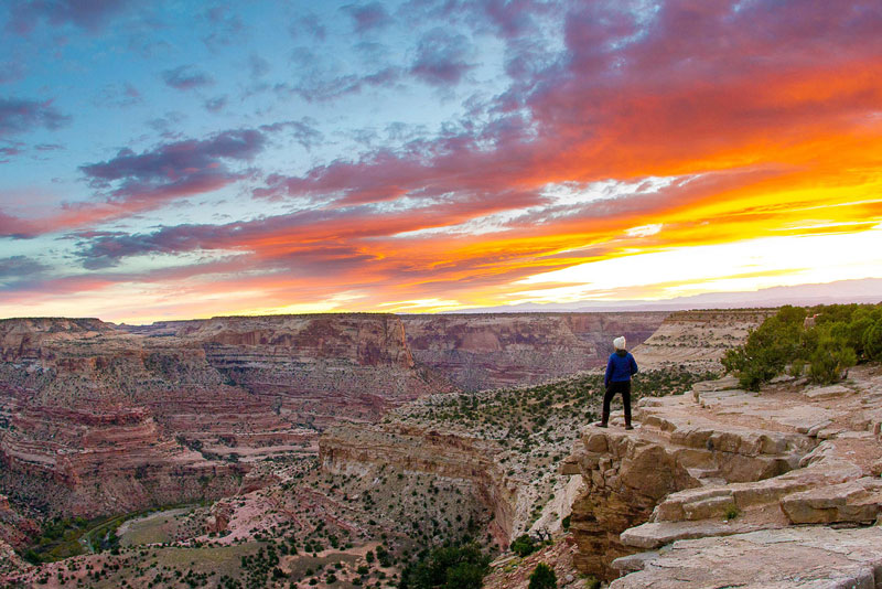
Our journey begins at a personal favorite spot, the Wedge Overlook. To some, the Wedge is a secret place that should not be shared, let alone featured in an adventure magazine. But share we will. Why? because it's too beautiful and amazing to not.
Standing on the edge at the Wedge (no pun intended) looking 1,200 feet down into The Little Grand Canyon is an amazing sight. The San Rafael River below meanders to create the curvy and beautiful canyons. Vivid colors, highlighting numerous shades of red, orange and brown creating 'eye candy' in all directions. It is late afternoon and sun is slowly making its decent. I decide to grab a chair and a beverage and just sit for a bit and watch as the colors of sunset slowly take this beautiful scene into something even more magical.
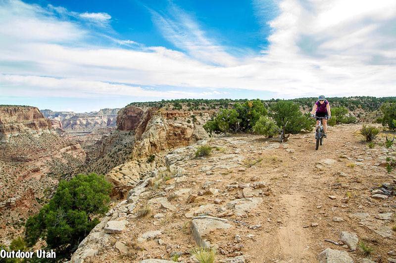
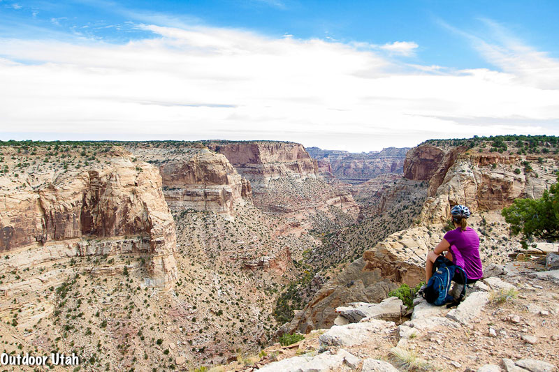 Good Water Rim Trail
Next let's go for a mountain bike ride. The Good Water Rim Trail is a 15-mile singletrack that parallels the edge of Good Water Canyon. The trail begins at the Little Grand Canyon overlook and takes you to the edge and back many times over. Offering breathtaking panoramic views at every corner, the trail boosts tight hairpin turns, rocky ledges, and fast, fun singletrack. I need to give special thanks to the long- time local and former sheriff of 33 years, Lamar Guyman, for creating this awesome trail. Good Water Rim was once one of those top secret, non-legit, local's only places, but now it is legal and ready for all comers! Allow extra time to stop along the way and admire the canyon beauty, one of the most scenic mountain bike rides in our beautiful state that numbers hundreds.
Grab your inflatable kayak or SUP! In most years, during the spring run-off season there is enough flow to run the Chute of Muddy Creek. Be sure to keep your eyes on the river channel because it changes quickly and the navigation challenge is very short lived. The Muddy Creek flows a total of 100 miles. The Muddy is a very ancient river course, superimposed on the San Rafael uplift and predates the time when the latter arose some 40-60 million years ago. Don't worry if you missed the window of opportunity to run the river - the hike through the "Chute" is one of the best of many in the Swell. The route is 15-miles and a shuttle is highly recommended. Beginning at Tomsich Butte and ending at the Hidden Splendor Mine, sections of this hike are often compared to the world famous Narrows in Zion National Park, but far less crowded and a bit more off the grid.
 Good Water Rim Trail
Rock art in the Swell is abundant and Black Dragon Wash is a great spot to see some of the best first-hand. The Black Dragon panel is named for the pictograph on the cliff wall resembling a large ancient flying dragon. This area is lush with both pictographs (painted) and petroglyphs (carved) from the ancient Fremont Indian culture that inhabited this area from about 500 to 1300 AD.
Perhaps the most dramatic element of the Swell is the San Rafael Reef, which dominates the eastern side. Driving I-70 or Hwy 6 one can see the huge uplift of Navajo sandstone. Erosion cut through the reef and polished the sandstone leaving many, many vibrant and colorful slot canyons. Some of these canyons are easily navigated and popular, like the Little Wild Horse/Bell Canyon loop. Others are extremely technical, like the Black Box, Lower Squeeze and Quandary, requiring canyoneering skills and knowledge of the area. Better yet, go with a guide.
Little Wild Horse (LWH) and Bell canyons make for a wonderful intro into slot canyon hiking since they are not technical and no ropes or canyoneering gear is required. Kids and first-timers love this hike. The trail is easy to find from Goblin Valley State Park and the ample parking lot has a restroom and directional sign board. The two canyons make for a loop, but it's best to start out through LWH and finish with Bell. The canyon slots up quickly and becomes so narrow that passing another hiker is difficult, if not impossible. Which is exactly why all hikers should go in the same direction — Little Wild Horse first, Bell last, not vice versa!
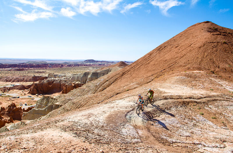 Goblin Valley State Park
That's all the good news about this wonderful hike. The not-so-good is that it's popular and often crowded. Goblin Valley is close by and the park has many desirable facilities and activities (two heated yurts, geocaches, hiking trails, modern restrooms, museum, etc.) not to mention the fabulous "goblins". Now the Utah State Park folks have added mountain biking into the mix. A beginner/intermediate 8-mile singletrack trail is now in place. The route overlooks the San Rafael Reef and is the closest thing Utah has to riding on the moon! Naturally, Goblin Valley is a popular destination and campers at the park flock to Little Wild Horse/Bell. There is, however, an alternative in the area — the colorful and colorfully named Ding and Dang canyons.
Ding and Dang are, respectively, the next two canyons to the west of LWH/Bell. While the neighbors to the east attract the crowds, Ding and Dang Canyon offer solitude even on popular holiday weekends. What's more, another reason why you won't find the crowds, is that they are more difficult yet offer a fun semi-technical adventure.
The easiest and much preferred loop is up Ding and down Dang since the latter has the most difficult obstacles. Ding Canyon has some small narrows, open sections bordered by towering walls and spires, and many interesting formations, several sections of scrambling, some cool potholes, and interesting geology as you head deeper into and ultimately all the way through the teeth of the San Rafael Reef. Here the terrain opens up near Ding Dang Dome (say that fast five times) towards the entrance to Dang Canyon, the obvious next canyon in the reef. Dang Canyon has more narrows, pinched-off slots, chockstone obstacles and often involves some wading through potholes. Basic canyoneering techniques like stemming, bridging and downclimbing dryfalls are required, moves not required in LWH/Bell.
Much of the San Rafael Swell is designated as Wilderness Study Area, so take maps and know before you go. The Swell is a vast wilderness and this only has just scratched the surface of this beautiful slice of Utah. If you haven't visited the Swell you need to! Chances are you'll surely have plans to return because this area, like no other, is truly magical!
Tags
Hiking, Mountain Biking, San Rafael Swell, Goblin ValleyArchives
- 2023
- 2022
- 2021
- 2020
- 2019
- 2018
- 2017
- 2016
- 2015
- 2014
- 2013
- 2012
- 2011
- 2010